
About Us
Tarbaj Constituency
Tarbaj is among the six constituencies of Wajir county , Located on latitude 2° 12' 30" N and Longitude 40° 7' 5" E on the Kenyan map. Tarbaj constituency has four wards namely Elben, Sarman, Tarbaj and Wargadud. The consitituency has a population of 57,232, land area of 9,650km2 and a population density of 6 as per the 2019 survey figures.
Constituency Area In Sq. Km (Approx.): 16.00
VISION
A model Constituency in Provision of Quality Education and Security services.
MISSION
‘ To prudently and effectively utilize funds allocated to the constituency for the socio-economic benefits of Tarbaj Constituents.
CORE VALUES
Tarbaj constituency is committed to upholding ; patriotism, Team work, integrity,responsiveness and Innovation and customer focus.
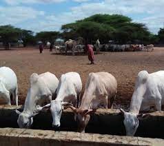
The inhabitants keep cattles , goats , sheep and camels to cushion themselves from ecomonic hardships.
They also engage in business activities.
Access NG-CDF Information on your Mobile


County Assembly Wards in Tarbaj Constituency:
Elben Ward
- County Assembly Ward No.:
- County Assembly Ward Name: Elben
- County Assembly Ward Population (Approx.):
- County Assembly Ward Area In Sq. Km (Approx.):
- County Assembly Ward Description: comprises part of
Sarman Ward
- County Assembly Ward No.:
- County Assembly Ward Name: Sarman
- County Assembly Ward Population (Approx.):
- County Assembly Ward Area In Sq. Km (Approx.):
- County Assembly Ward Description: comprises part of
Tarbaj Ward
- County Assembly Ward No.:
- County Assembly Ward Name: Tarbaj
- County Assembly Ward Population (Approx.):
- County Assembly Ward Area In Sq. Km (Approx.):
- County Assembly Ward Description: comprises part of
Wargadud Ward
- County Assembly Ward No.:
- County Assembly Ward Name: Wargadud
- County Assembly Ward Population (Approx.):
- County Assembly Ward Area In Sq. Km (Approx.):
- County Assembly Ward Description: comprises